While the north gets pretty leaves, cool weather, and picturesque scenes, Florida gets stormy weather, humidity, and hurricanes. I have lived in Florida for almost eleven years, and I can accurately say that this is true; it’s almost abnormal to experience a fall without at least one hurricane or some form of a tropical disturbance.
While I may have more hurricane experience than the average first-year student, this fall was like nothing I had ever experienced before.
On Thursday, September 26, Hurricane Helene made landfall in the panhandle of Florida as a Category 4 hurricane. In anticipation of potential impacts to the Central Florida area, Rollins decided to cancel classes for the day but allowed students to stay on campus.
Just over a week later, Hurricane Milton formed in the Gulf of Mexico and set its sights right on Orlando.
What exactly is hurricane season though?
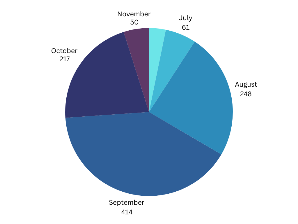
Officially, hurricane season runs from June 1 to November 30, while the peak runs from mid-August to mid-October when the waters in both the Gulf and the Atlantic are the warmest. That means that as students are settling into their college routines, a hurricane is bound to come and disrupt it.
Sometimes that will only be a day, like in the case of Helene, but other times, as such with Milton—or Hurricane Ian back in September 2022—the disruption is more than just the canceling of classes, uproooting many students back to their homes.
I spoke to Leon Hayner, Dean of Student Affairs, about how Rollins prepares for and handles hurricanes, such as Milton, and I asked him how the decision is made to evacuate campus rather than to just cancel classes. He said there are three specific factors when it comes to making decisions surrounding hurricanes: the strength, the size, and the path of the storm.
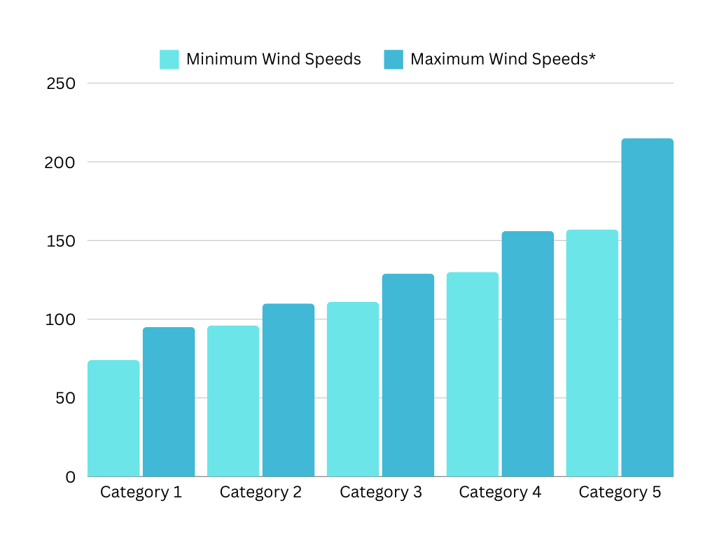
Hurricanes are classified based on the Saffir-Simpson scale, which is defined by the windspeeds reached by a hurricane between a certain point. It is worth noting that for those new to understanding hurricanes, there is no “maximum windspeed” for a Category 5 storm, though the highest windspeeds ever reached were 215 mph during Hurricane Patricia in 2015.
Milton, at its peak, reached speeds close to 180 mph, making it one of the strongest hurricanes to ever be recorded.
On Sunday, October 6 around 2 p.m., an email was sent by the Rollins Public Information Team notifying students that mandatory evacuations were in place for the campus and that all students had to leave by Tuesday at 5 p.m.
I was in the library working on a Sandspur article and watching a football game when I received the Outlook notification on my phone. I immediately called my mom and let her know what was happening, then headed back to my dorm to start packing.
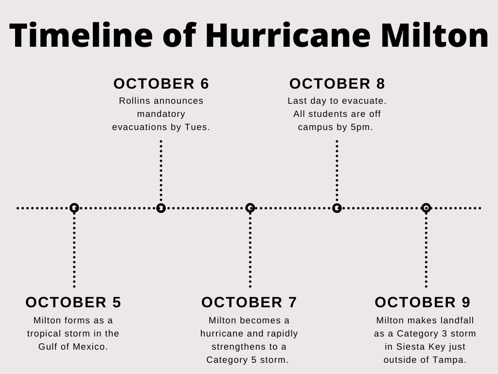
While many students were scrambling to arrange flights for the next morning, I just had to make a 30-minute drive west. That meant while my evacuation plans were simple, I was going to be right in the path of the storm.
Orange County schools closed on Tuesday afternoon—while we wouldn’t receive major impacts from Milton until Wednesday afternoon, school buses are not allowed to run when the winds reach a specific speed leading to the closure of schools—and so with my entire family home, we began to hunker down to ride out Milton.
As with all events, everyone handles them differently. For us, that meant having the television turned to the Weather Channel or our local news station all day, watching as the same people who covered Helene in Tampa were now in neighborhoods like my own.
A word of advice for those who are new to Florida, if the Waffle House closes and/or Jim Cantore—the lead meteorologist for the Weather Channel—shows up, that’s when you know to run. While the Waffle House index may sound like another “Florida Man” thing, it is an unofficial scale designed by FEMA to measure the severity of a hurricane.
Wednesday rolled around and with it came Milton. The biggest issue with hurricanes, I feel, is that so much time is spent waiting in anticipation that when the hurricane arrives it is almost a letdown in a way—not to mention that most hurricanes make landfall overnight, so you are almost definitely bound to sleep through them.
The day was spent inside as the rain came down, switching between the Weather Channel, episodes of “Modern Family,” and whatever annoying YouTube videos my brother was watching. I spent much of the day in my room with my cat, listening to the raindrops falling outside, trying to churn out as much homework as I could—the aftermath of a hurricane is always unpredictable.
Around 8 p.m. that night, the winds from Milton’s outer bands officially made their way onto land and spawned one of the worst tornado outbreaks from a hurricane in history. For anyone who lives or has previously lived in the Pacific Northwest, particularly on the coast, the winds of hurricanes are remarkably similar to that of the fall storms experienced during the October and November months. The winds though are not necessarily the worst part of the hurricane; for many people, the risk of flooding is what causes the most damage.
When Thursday rolled around and the clouds cleared and the sun came out, the damage assessment began.
While much of the Central Florida area was spared from major damage, there were still widespread effects felt.
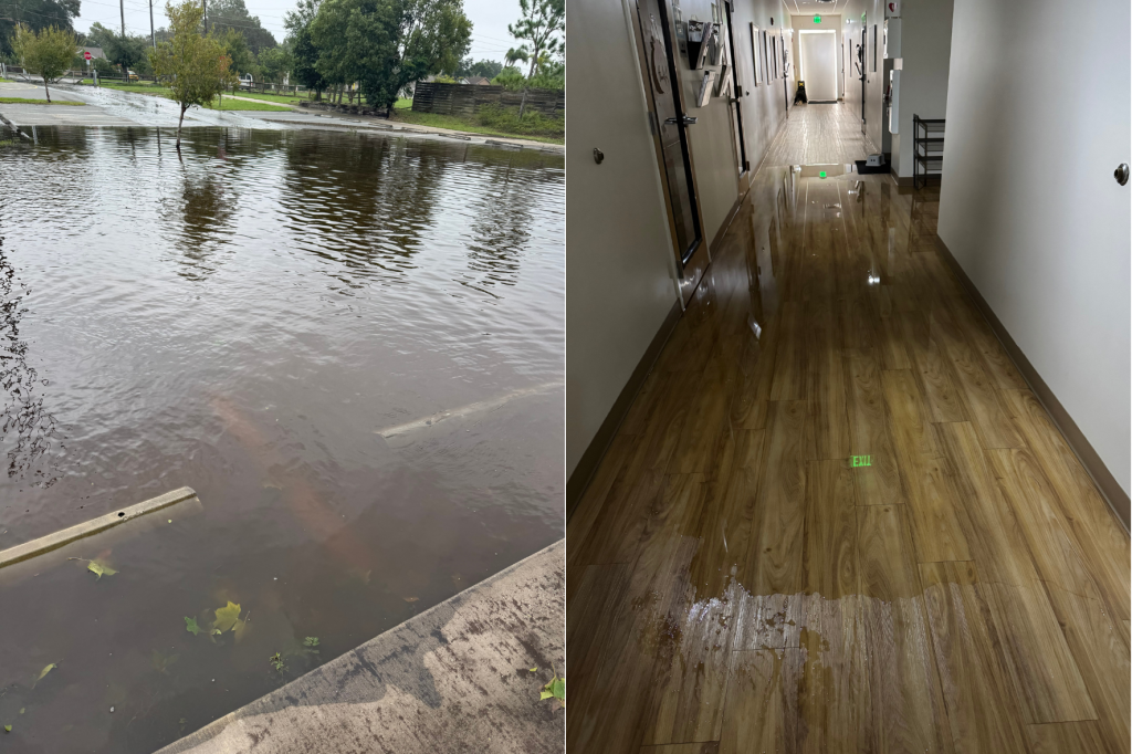
This is what the school I previously attended looked like following Milton. While the Orlando area may have been spared from any major wind damage, the flooding wreaked havoc from the West to the East Coast.
Thankfully, there was no major damage caused to the building, and the result was the relocation of the two classes that flooded so that work on replacing the floors and walls that received water damage could begin.
At Rollins, the damage assessment began for a hopeful reopening that weekend. Luckily, the damage was minimal, and students could move back on the Saturday after the storm.
I remember the first time experiencing a hurricane and how scared I was for the potential it could bring. So often you see stories in the news about entire homes and communities being ripped to shreds—Katrina in 2005 comes to mind here—and with the first hurricane, you always wonder, “Could that be me?” So, for many first-year students there is a fear of the first hurricane and whether you will return to a campus that is fine or have to replace everything you left behind is scarier in a way than experiencing the actual event.
By the fourth or fifth one, you will be a pro, whether you are a Florida native or not. Consider Milton to be your Florida initiation.
The opinions on this page do not necessarily reflect those of The Sandspur or Rollins College. Have any additional tips or opinions? Send us your response. We want to hear your voice.




[…] occur after hurricanes, including Hurricane Ian in 2022 and Hurricane Milton in 2024. Tovar said, “It’s an exceptional situation. Even at Disney, […]